Ephesus
The Temple of Artemis, which was considered to be one of the Seven Wonders of the World, is situated on the edge of this small town. The city which was situated at the beginning of the Persian Royal Road has survived sufficiently enough to enable us to understand the ancient way of life in Ephesus. It is one of the cities which played an impressive role in the beginnings of Christianity and during the period of its proliferation (St.John Church and the shrine of the Virgin Mary). It contains one of the most spectacular examples of religious architecture of the Seljuk Period.
http://whc.unesco.org/en/tentativelists/665/
The Ephesus Museum, which is responsible for archaeological research, reorganization, supervision and protection on behalf of the Ministry of Culture, is one of the most important museums in Turkey not only with the works from Ephesus and nearby places belonging to Mycenaean, Archaic, Classic, Hellenistic, Roman, Byzantine, Seljuk and Ottoman periods, but also with cultural activities and capacity of visitors.Having been found as a storehouse after the excavations in Ephesus in 1929 and expanded with an additional building in 1964, The Ephesus Museum was improved by means of changes in exhibitions and new additions.
Since The Ephesus Museum includes relics from a single antique city, the works are exhibited according to places where they were unearthed rather than a typical and chronological way of exhibition. To this end, exhibition halls are organized as Slope Houses and House Findings Room, The Section of Coins and Treasure, The Hall of The Funerary Relics, The Hall of Artemis, and The Hall of Imperial Cults. Besides these halls, many architectural works and sculptures are exhibited within the museum and the courtyards in harmonization with the garden decoration. Two Artemis sculptures, the bust of Eros, the statue of Eros with dolphin, the bust of Socrates are some of the worldwide known works exhibited in The Ephesus Museum.The Ephesus Museum possesses about 50.000 works in its collections. The number increases every year thanks to the ongoing archaeological excavations and donations from the local and neighbouring communities. In order to present these works to the service of scientific world and humanity sooner, ‘The Hall of New Findings’ has been found within The Ephesus Museum. However, this hall is not always enough for exhibiting numerous numbers of works. So, the other halls within the museum are needed to be renovated in the light of new findings according to modern museological principles.In accordance with this perception, groups of findings are being exhibited together after the last arrangements within The Hall of Slope Houses and House Findings so as to ensure the unity of theme. The hall includes many indispensable requirements in daily life from every century such as medical and cosmetic tools, jewels, weights, lighting tools; music and entertainment findings, examples to weaving tools; sculptures used in house cult and decoration, sculptures and busts of gods, goddesses and emperors, and furniture. One section within The Hall of Slope Houses is called ‘Socrates Room’ which is decorated with frescos, mosaics, and furniture as well as including dummies.
New sections of The Ephesus Museum open to visitors upon recent arrangements the museum, Ephesus and Selçuk:
1- Arasta and Bath House Section: Adjacent to the courtyard, this section, which is an integral part of the museum, exhibits commercial life in old Turkish towns, and various handicrafts that face extinction. This area can be found adjacent to the central garden of the museum. The department displays various stages of the cereal grinding process (mills), which played a significant part in agricultural local life as well as various types of copperware and beads produced to avert the evil eye. Within the section where Turkish tents are exhibited examples to old Turkish architecture and an Ottoman bath house dating back to 16th century are open to visitors.
2- Ayasuluk Library: An old Turkish building (14th century) in the back street of The Ephesus Museum was restored by the museum, and it was designed as a small library where the public could read books and daily newspapers.
3- The Museum for the Visually Impaired: In the Ephesus antique city, one of the restored shops in the lower Agora has been turned into a museum specific for the visually impaired. The museum consisting of two sections includes original and replica works of art.
http://www.goturkey.com/content.php?cid=51570&typ=c&lng=en
Hagia Sophia
Hagia Sophia is considered a unique monument in world architecture, and it’s magnificence and functionality has been a good example in construction of countless Ottoman mosques. Hagia Sophia with its exceptional history constitutes a synthesis between east and west. This monument is one of the wonders of the world that has remained intact until the present day. One can find many attractions in Hagia Sophia – interesting forms of Byzantine architecture, mosaics of the Christian period as well as structures added during the Ottoman era.
Hagia Sophia has been a Christian place of worship for 916 years, then converted into a mosque and served Muslims for 481 years. Hagia Sophia Museum was opened in 1935 and ever since it has been attracting thousands of visitors every year.
According to Byzantine historians (Theophanes, Nikephoros, Grammarian Leon) the first building of Hagia Sophia church was established during the reign of Constantius I (324 – 337 AD). It was a basilica with a wooden roof, and it was burned down during a revolt. Nowadays there is no evidence of this structure.
During the reign of emperor Theodosius Hagia Sophia was built for the second time and opened to the public in 415 AD. The basilica was again burned down during the Nika Revolt in 532 AD. Some ruins of this building were discovered during excavations in 1936. There were stairs indicating the entrance of the building, columns, capitals and other fragments of the building.
Emperor Justinian (527 – 565 AD) wanted to build a church bigger than two previous ones, which would represent the power and magnificence of empire. The new building of Hagia Sophia was made by two famous architects of that era – Isidoros from Miletos and Anthemios of Tralles. Many columns, capitals, marble and colourful stone were brought to Istanbul from various ancient cities in Anatolia and used in construction works of Hagia Sophia.
The works were commenced on December 23, 532 AD and completed on December 27, 537. The new building consisted of a large central nave and two side aisles, separated by columns, apse, inner and outer narthex. The size of the inner space of basilica is 100 X 70m and it is covered by the magnificent dome (diameter 30.31 m), supported by the four large piers, 55 m high.
Besides the unique architecture of the building, the mosaics are also important artefacts of the period. The oldest mosaics – gold gilded with geometrical and floral designs – may be found in the inner narthex as well as in side naves. Figural mosaics (with images of Jesus Christ, Virgine Maria etc.) from 9th – 12th centuries are located on Emperor Door, apse, exit doors and upstairs gallery.
After the conquest of Istanbul in 1453, the so-called ‘Turkish period’ started, and several repairs were made in Hagia Sophia. The art works surrounding the mihrab includes the best samples of Turkish pottery and calligraphy. The sure is taken from the Koran inscribed on rounded plates of 7.50 m diameter by Kazasker Mustafa Izzet Efendi, a famous Ottoman calligrapher. The names of Allah, Muhammed, Omer, Osman, Ali, Hasan, Ebu Bekir and Huseyin are inscribed there. On the sidewalls of mihrab there are plates written and granted by Ottoman sultans.
Tombs of Sultan Selim II, Sultan Mehmet III, Sultan Murat III as well as some of their relatives, fountain of Sultan Mahmut I, primary school, soup kitchen, library, Sultan Abdulmecit’s meeting place and the mosque timekeeper’s (astronomer’s) house may be found in the territory of Hagia Sophia Museum. All of the above mentioned objects, especially the tombs with their interior design, pottery and architecture are excellent examples of Ottoman tradition.
http://www.goturkey.com/content.php?cid=47518&typ=c&lng=en
Topkapi Palace Museum
Topkapı Palace, which was used as the centre of administration and residence of dynasty in İstanbul the capital city of the Ottoman Empire, was completed in 1473 only two decades after Fatih Sultan Mehmet conquered the city. Members of the Ottoman dynasty inhabited in the palace until they moved to the Bosphorus Palaces in the 19th century. By the order of Atatürk, Topkapı Palace was opened to visit as a museum after the proclamation of the republic in April 3, 1924. In the process of time, magnificence and the multi-functionality of the palace protocol and hierarchy was reflected to the architecture of Topkapı Palace. Even the palace became the artistic account of the growth and the fall of the state. With its process of dramatic events decorating the great history of Ottoman Empire, the palace is one of the rare examples to the museums in the world that could reach today with their historical backgrounds. Topkapı Palace is built on the Byzantine acropol situated in Seraglio-Point (Sarayburnu) which forms the headland for the historical İstanbul peninsula; between Marmara Sea, The Bosphorus and the Golden Horn. The Palace is seperated from the city by Sûr-ı Sultâni at the side of land which was built by Fatih, and at the side of the sea; by city walls of Byzantine. Besides a variety of doors with different functions and sea and land doors; Bâb-ı Hümâyûn (The Imperial Gate) which is situated behind Ayasofya forms the monumental door of the palace. The reflection of the functional simplicity needed for a strong state which had experienced all kinds of splendour and protocol details for centuries is clear from the entrance of the palace. This gate, with its character in the 15th century, suits the castle-palace construction. Above the gate through which the public could enter there used to be a manor house that could stand up by the 19th century. It is known that regiments were watched from the manor house and special treasures were preserved in it.
http://www.goturkey.com/content.php?cid=47647&typ=c&lng=en
Topkapi Palace was home to all the Ottoman sultans until the reign of Abdulmecid I (1839-1860), a period of nearly four centuries. The order for the construction of the Topkapi Palace on the Seraglio Point overlooking both Marmara and Bosphorus was given by Mehmed II after the conquest of Constantinapolis in 1453. The place was then an ancient olive grove. The final form of the first palace covered an area 700m², and was enclosed with fortified walls 1400 meters in length. The walls were pierced by a number of gates, namely the Otluk gate, the Demir gate and the Imperial gate (Bab-i Humayun), and a number of minor angled gates between them. After the reign of Mehmed II the Conqueror, the palace grew steadily to form a city like complex of buildings and annexes, including a shore palace known as the Topkapi shore palace, as it was situated near the cannon gate -Topkapi- of the ancient walls of Istanbul. When the shore palace was burned down in 1863, it lent its name to the great complex we now know as Topkapi Palace. The main portal, the Bab-i Humayun, was suited next to the mosque of Ayasofya (Haghia Sophia Church), and this led a series of four courts surrounded by various structures. The courts, chambers, pavilions and other sections can be viewed at the floor plan of Topkapi Palace.
In this page, you can find pointers to the pictures of illuminated manuscript pages in the museum sections and pictures of sections illustrating the architecture of the palace.
Today Topkapi Palace functions as a museum and only a very small part of its original domain and environment can be appreciated. The ravages of time have resulted in the destruction (by fire) and the demolition (through new building) of many of its original structures. Despite this, the original 15th century spatial organization based on a triple courtyard order that integrates, segregates, and defines the palace’s residential, ceremonial, and functional requirements has remained remarkably intact. These individual requirements led to the formation of homogeneous, self-contained clusters that evolved around smaller courtyards since this was dictated by the formative systems of the social and functional groups, corps, classes, and institutions that occupied them. These clusters are not isolated, however, but are linked to and aligned with the main courtyards creating a self- contained microcosm that perfectly mirrors the state it housed.
That then defines the methodology of this book. By analytically exhibiting the spatial hierarchy of the palace, reconsidering its order and the successive stages of its transformation, we shall endeavor to expose the present state and past of this unique world, the Palace of Felicity.
http://www.ee.bilkent.edu.tr/~history/topkapi.html
Cappadocia ( Goreme Open Air Museum )
First structure is monastery of nuns at the Goreme open air museum. In fact, the monastery of nuns known as six or seven floors but can be visited only three floors yet. The connection between the floors of the monastery is provided with tunnel and tunnel entrance are closed with sliding stones like underground cities of Cappadocia. There is a dining hall in the first floor, second floor has a chapel which decorated with frescoes and third floor also has a church with geometric decoration. There is Monastery of Priests near the Monastery of the nuns. Only a few rooms on the ground floor can be visited for into the rock layers are destroyed. A little later there is Hagios Basileos church which is known a tomb chapel walls decorated with frescoes. Near this church there is Aynali monastery with places around a courtyard. Aynali monastery has a big room which suppositional meeting room, a church and tomb rooms. Elmali monastery, for many years been used as a loft, all entries have been closed and thus without destroying frescoes hardly reached today. Understanding that the church is decorated in two differnet periods by means of red paint figurative decorations bottom of the poured frescoes. There is Barbara Church behind the Elmali monastery, Barbara Church walls are decorated with geometric figures and animal pictures. Just ahead Church of Hagia Katherina’ frescoes largely damaged. Yilanli church has a church, refectory, and other places. It has been named as Yilanli Church (Church with snake) for on one of the frescoes St. Georgios fight with a dragon on a horse.
How can you go: Goreme open air museum is near the Goreme town of Nevsehir province. Nevsehir is 670 km. far from Istanbul, 280 km. from Ankara, 750 km. from Izmir. Goreme is 15 km. from Nevsehir center, you can go by bus, minibus or taxi to Goreme from Nevsehir. You can go by walking to museum from Goreme in 20 minutes.
http://www.cappadociaturkey.net/goreme_open_air_museum.htm
The entrance fee to the museum is 15 TL per person. In summer, it is better to visit the museum early in the morning or late afternoon, instead of mid-day. There are many churches and chapels in Goreme Open Air Museum but the most important ones are:
Nunnery
The 6-7 storey rock mass to the left of the museum entrance is known as “the Nunnery”. The dining hall, kitchen and some rooms on the first floor, together with the ruined chapel on the second level, can still be visited. The church on the third storey, which can be reached through a tunnel, has a cruciform plan, a dome with four columns and three apses. The templon on the main apse is rarely found in Goreme’s churches. Besides the fresco of Jesus, painted directly onto the rock, designs painted in red can also be seen. The different levels of the monastery are connected by tunnels, and “millstone doors”, such as those found in the underground cities, and were used to close off these tunnels in times of danger.
St. Barbara Church
This church is situated behind the rock housing Elmali (Apple) Church. It has a cruciform plan, with two columns. The north, south and west arms of the cruciform are barrel vaulted, and the center, the east arm, and the east corners are domed. There are a main, central apse and two side apses. Motifs were painted in red directly onto the rock. The walls and the dome are decorated in a variety of motifs including geometrical patterns, mythological animals and military symbols. The walls also have motifs resembling stonework. This church dates back to the second half of the 11th century.
Apple (Elmali) Church
One of the most prominent buildings in the area with its vivid colors, the church is a groin-vaulted structure with cross-in-square plan, having four columns and a central dome. It has beautiful frescoes dating to the 11th and 12th centuries. And where these have fallen off, you can see simple red-painted ornaments from the iconoclastic period. The frescoes are narrating scenes from the Bible and the life of Christ, the Hospitality of Abraham and Three Hebrew Youths. The building derives its name from the apple orchard collapsed a long time ago, in front of the main entrance.
Snake (Yilanli) Church
This church has a linear plan, consisting of two chambers. The front section is barrel-vaulted, while the back one has a flat ceiling. The red ochre ornaments imitate hewn stone plait. Frescoes dated to the 11th century, are painted directly on the wall. Opposite the entrance, there is an image of Christ with a book in his hand, and at his left, on both sides of a large cross, are Emperor Constantine and Helena. Right next to it, the Killing of the Snake by St. George and St. Theodore is depicted. On the opposite wall, Onophrios can be seen with a sapling in front of him, also the Apostle Thomas, and the founder of the building, St. Basileios holding a book in one hand and sanctifying with the other.
Dark Church (Karanlik Kilise)
The entrance to this church is from the north through a winding tunnel which opens into a barrel-vaulted narthex. You have to pay an extra admission fee (8 TL per person) but it is surely worth it. In the south of the narthex there are three graves, two of which are big and the other, small. The church has a cross plan, the arms of the cross having a diagonal vault. The templon of the main apse has been destroyed. This Church dates to the end of the 12th century. Some of the scenes on the walls are Deesis, Annunciation, Journey to Bethlehem, Nativity, Baptism, Raising of Lazarus, Transfiguration, Entry into Jerusalem, Last Supper, Betrayal of Judas, the Crucifixion and Anastasis.
Carikli (Sandals) Church
This two columned church (two other columns being in the form of pillars), is cross vaulted, and has three apses and four domes. The well preserved frescoes show the life of Jesus, Hospitality of Abraham, and images of the saints and the donors of the church. Although it resembles both the Karanlik (Dark) and Elmali (Apple) Churches, the scenes of the Way of the Cross and the Descent from the Cross make this church different from the others. The figures are generally large. The footprints under the Ascension scene give the church its name, which means “with sandal”. The church dates back to the end of the 12th and the beginning of the 13th centuries. The center dome houses a picture of Jesus the Pantocrator with the busts of angels in the insets. On the central apse is Deesis, on the north apse Mary and the Baby Jesus, and on the south apse, a picture of St Michael.
Buckle (Tokali) Church
Even though Tokali church is located down the museum around 50 meters, you can visit the church with the same ticket that you used for Goreme Open Air Museum. It is a complex made up of 4 main chambers. The entrance to the New Church having a rectangular plan with longitudinal axis is made through the barrel-vaulted single-naved Old Church. This rock settlement is divided with arches into three sections. Containing the most important samples of paintings, the building has been decorated in various periods.
In the Old Church section, frescoes dated to early 10th century, painted in bands of rich red and green, represent scenes from the Bible. The indigo dominating the main chamber frescoes in the New Church, is a feature discerning the structure from the others. Among the rock churches in Cappadocia, Tokali has the best paintings narrating the life of Christ in the most detail. The church is decorated with the Infancy (childhood of Christ), Ministry and Passion cycles, with several episodes from the life of St. Basileios.
http://www.goreme.com/goreme-open-air-museum.php
Ankara Etnography Museum
The Ethnography Museum is the museum, where Turkish art from Seljuk era to the present time is exhibited.Public clothes, jewellery, shoes, slippers, samples collected from various regions of Anatolia, womens and mens socks from Sivas region, various bowls, laces, scarves, belts, handkerchiefs, bed sheets, bride costumes, bridegroom shaving sets, old traditional Turkish art are exhibited.Technical material and designs unique to Turks and carpets, weaving benches from Uşak, Gördes, Bergama, Kula, Milas, Ladik, Karaman, Niğde, Kırşehir regions are on display. Among fine art samples of Anatolian Mine arts, there are Mamluk boilers from 15th century, Ottoman sweet boilers, hand washing jugs, trays, coffee trays, meal tables, cups, candle scissors etc. are exhibited.Arrows, bows, lighting pistols, rifles, sword and other things from Ottoman period, Turkish pottery and porcelain and Kütahya porcelains, religious and sect properties, Turkish inscriptions are exhibited with the nice samples.
http://www.goturkey.com/turkiye.php?lng=en&content=museums
Catalhoyuk
Çatalhoyuk lies on the Konya plain on the southern edge of the Anatolian Plateau at an elevation of just over 1000m above sea level; the highest point of the East mound of Çatalhöyük is 1020.3m above sea level, 16 m above the surrounding plain. Çatalhöyük lies within the village boundaries of Küçükköy, a small village of approximately 100 hundred houses located one kilometer to the north of the site. The sub-province centre of Çumra is 12km south/southwest of the site and the provincial capital of Konya is 60 kilometers away in northwestern direction.
The site Çatalhöyük is made up of two mounds: Çatalhöyük East and Çatalhöyük West. The east mound is clearly visible from some distance: the west mound is much lower with gently sloping topography. Çatalhöyük east consist of 21m of Neolithic deposits dating from 7400-6200 B.C. with some later deposits consisting mainly of Byzantine burials and rubbish pits. Çatalhöyük West is 6m high and is almost exclusively Chalcolithic (6200-5200 B.C.), again with the presence of some Byzantine burials.
The two mounds built up on either side of the Çarşamba Çay River which ran between the two mounds during the Neolithic period. Çatalhöyük was discovered in the 1950s by James Mellart. It was the largest known Neolithic site in the Near East at that time. Çatalhöyük East is 450m in length and 275m in width, approximately 23 acres.
The site represents significant social change and development: hunting taking place alongside the domestication of plants, the invention of pottery, and coming together of 1000s of people in a permanent settlement. Furthermore the two mounds span over 2000 years and indicate a high degree of continuity though time.
Excavations which restarted in 1993 and continue today have reached the bottom of the East Mound and have discovered a total of 18 levels of occupation. Sampling has been undertaken of the whole site and society was egalitarian without large-scale centralized administration. Shelters have been built over excavated portions of the site, a Visitor Centre and experimental house have been constructed, facilities have been provided, and there is a Site Management Plan.
http://whc.unesco.org/en/tentativelists/5410/
Corum Archaeology Museum
Çorum and its locals have been demonstrating a considerable interest in archaeology since the first initiatives of Atatürk in 1935 to launch the excavations in Alacahöyük. In addition to those of the Alacahöyük excavations, the unique handicrafts found at Boğazköy, Ortaköy, Eskiyapar, Pazarlı, Kuşsaray and Alişarhöyük had enriched the collections at hand and provided the Çorum Museum with valuable assets when it was first founded in 13 October 1968. Throughout time, the collections have become even richer by exceptional purchases. Besides archaeology, the museum has dedicated a well-designed section to ethnography which successfully depicts the local culture and life. The Boğazköy Museum, which is founded in 1966 in the area of Hattushash, the ancient capital of Hittite, is also affiliated with the Çorum Museum.
http://www.goturkey.com/turkiye.php?lng=en&content=museums
The Museum of Anatolian Civilizations
Selected the European Museum of the Year in 1997, the Museum of Anatolian Civilizations is located on the hill with Ankara’s ancient Citadel, in the district called Atpazari (the horse market). The Museum occupies two Ottoman buildings which have been specifically renovated and altered to suit their new role.
In accordance with the suggestion by Atatürk that a Hittite Museum should be established, an Anatolian Civilizations project was initiated to gather all artifacts, remnants and other findings of the Hittite civilization in Ankara. Thus launched, the project has grown into one of world’s most significant museums sheltering unique collections. The museum has Paleolithic, Neolithic, Chalcolithic, Late Bronze Age, Hittite, Phrygia, Urartu and Late Hittite sections.
http://www.goturkey.com/turkiye.php?lng=en&content=museums
Antakya Archaeology Museum
Scientific excavations were started for the first time in 1932 in Hatay and collected Roman art 2 and 3 centuries old, are the property of Antoninus and Severius period .Roman and Byzantine mosaics found in to the structure of Zeus, Tethys Okeanos, Apollon, Psykhe, Eros, Satyros, Aphrodite, Baccus .Construction of the the Hatay Archaeological Museum began in 1934, inspired in part by the excavations of ancient Antioch that began in 1932 and on the recommendation of the French archaeologist M. Prost. The museum was completed in 1938, and a year later the Hatay province was reunited with Turkey. The museum was reorganized and reopened in 1948, and again in 1975.The collection of the Hatay Archaeological Museum is spread throughout seven rooms and two halls, arranged according to where the artifacts were found. The rooms are tall and full of large windows, providing plenty of natural light. Most of the labels are in Turkish and English.
One of the most famous mosaics in the Antakya Museum is the Megalopsychia Hunt Mosaic, a large mosaic pavement dating from 450-75 AD. Discovered in Yakto village near Daphne, the mosaic is especially celebrated for its border, which depicts major landmarks and daily activities in ancient Antioch and Daphne. It is an important source for archaeologists, since virtually no structures from these ancient cities survive today.Other highlights of the superb mosaic collection include the Boat of Psyches, the Drinking Contest, a rare Menander with Glykera and Comedy, the Buffet Supper with dishes full of ancient foods, and the magical Evil Eye mosaic that was intended to deflect curses from a 2nd-century home.
http://www.goturkey.com/turkiye.php?lng=en&content=museums
Zeugma Mosaics Museum
Zeugma is an ancient city of Commagne, currently located in the town of Nizip, forty-five kilometers away from Gaziantep.The significance of Zeugma is the Roman villas and their floor mosaics. Zeugma had captured the public attention, when the Birecik Dam Project brought up the possibility that Zeugma could have been inundated under the dam’s waters. Majority of the Roman villas were brought to day light within the framework of a rescue excavation which was intensified in 2000. Yet, the total of the excavations, which were originally started in 1987, have discovered only a small number of these unique mosaics. Today in the Zeugma Mosaics Museum 500 meter square-wide mosaics, 35 mosaic panels as well as the famous 1, 50 cm-long bronze Mars and Aphrodite statutes are in display. The museum is proudly the second biggest mosaic museum of the world.
http://www.goturkey.com/turkiye.php?lng=en&content=museums
Antalya Archaeology Museum
Antalya Archeological Museum is one of Turkey’s largest museums, located in Konyaaltı, Antalya. It includes 13 exhibition halls and an open air gallery. It covers an area of 7,000 m² and has 5000 works of art are exhibited. In addition a further 25 – 30,000 artifacts which cannot be displayed are in storage. As a museum exhibiting examples of works, which illuminate the history of the Mediterranean and Pamphylia regions in Anatolia, Antalya Museum is one of the most important of Turkey’s museums. The Museum won the “European Council Special Prize. The Museum exhibition rooms are as follows: Natural History Hall, Pre-History Hall, Proto-History Hall, Classic Period Hall, Statuary Hall, Hall of Small Objects, Hall of Imperial Statues, Sarcophagus Hall, The Mosaic Hall, Hall of Coins, Turkish – Islamic Period Works, Ethnographic Hall, Children’s section.
http://www.goturkey.com/turkiye.php?lng=en&content=museums
Ankara Etnography Museum
The Ethnography Museum is the museum, where Turkish art from Seljuk era to the present time is exhibited.Public clothes, jewellery, shoes, slippers, samples collected from various regions of Anatolia, womens and mens socks from Sivas region, various bowls, laces, scarves, belts, handkerchiefs, bed sheets, bride costumes, bridegroom shaving sets, old traditional Turkish art are exhibited.Technical material and designs unique to Turks and carpets, weaving benches from Uşak, Gördes, Bergama, Kula, Milas, Ladik, Karaman, Niğde, Kırşehir regions are on display. Among fine art samples of Anatolian Mine arts, there are Mamluk boilers from 15th century, Ottoman sweet boilers, hand washing jugs, trays, coffee trays, meal tables, cups, candle scissors etc. are exhibited.Arrows, bows, lighting pistols, rifles, sword and other things from Ottoman period, Turkish pottery and porcelain and Kütahya porcelains, religious and sect properties, Turkish inscriptions are exhibited with the nice samples.
http://www.goturkey.com/turkiye.php?lng=en&content=museums
Santa Claus (Saint Nicholas ) Church /Museum
Santa Claus, or Saint Nicholas, is called “Noel Baba” in Turkey. While the popular myth is that he lives at the North Pole, he actually lived and died in Turkey during the fourth century. He was the Bishop of Myra, now called Demre, near Antalya. A Byzantine basilica in Demre honors his memory, and the tale of his generosity is not forgotten in Turkey. The story is of a bishop tip-toeing through the streets of old Myra to toss bags of gold through open windows or down chimneys. He is said to have been the sole heir of a wealthy family and shared his money secretly with the less fortunate. Among many others, one story told how he gave a nobleman three sacks of gold for his daughter’s dowries because the nobleman was too poor to pay the dowries himself. The first two bags, he tossed through an open window. But when he found the window tightly shut on his third visit, he went down the chimney instead, dropping the sack in a red sock that was drying on the mantlepiece.
Since then, it has become a tradition to put oranges in Christmas stockings to symbolize the sacks of gold. Also, the three golden balls that pawn shops use as their symbol originated from this story. After Saint Nicholas died in 323 A.D., his priests buried him in an elaborate marble sarcophagus they periodically filled with fragrant oil. The oil dripped through cavities in the sarcophagus, and the priests did a lucrative business selling vials of it to pilgrims wo believed the oil had miraculous powers. The Saint Nicholas church was built in his memory after his death. The church is one of the oldest in Turkey, dating from the fifth century. Tales of Saint Nicholas spread westward and in April 1087 merchants from Bari, Italy, opened the Saint’s sarcophogus and took his bones to Italy believing they would bring them weath. Other stories have it that Saint Nicholas was moved so he would be buried in a Christian land. Based on that event, the cities of Bari and Antalya were declared sister cities several years ago. A few pieces from Saint Nicholas’ sarcophagus are on display in the Antalya museum.
In 1886, a Russian prince had the church restored by an architect. Instead of the cupola, a crosswise arch unrelated to Byzantine architecture was placed there and a belfry was added. The sarchopagus found inside the western apse is believed to be Saint Nicholas’. Every year on December 6th, the day Saint Nicholas died, there is a service in Saint Nicholas’ Church in Demre. This is also the first day of a week-long festival held in Demre sponsored by the Santa Claus Foundation. There is a bronze statue of Saint Nicholas in Demre, erected in 1981, which looks very much like the typical Santa Clause with a long beard, a sack over his shoulder, and a group of small children gathered around him.
http://www.turkeycentral.com/articles/featured_article.php?article_id=30
Trabzon – Sumela Monastery
Sumela is a monastic complex built into the rock cliffs of the Altmdere Valley. It is construction began in 385 AD; and continued until the 19 th century. Barnabas, a monk from Athens and his nephew Sophronios built the section which comprised the first two rooms of the monastry in rocks. The Byzantine Emperor Justinian (AD 527-568) ordered the enlagement of the monastery. The monastery was looted and burnt by the Byzantines in AD 650. However the Comnenids restored and enlarged the monastey. The monastery with its 72 rooms and a rich library, lived its most flourishing time during the period of Alexios III 8 Michael I.
http://whc.unesco.org/en/tentativelists/1397/
Mevlana Museum
At the very heart of Konya, in more ways than one, is the Mevlâna Müzesi (Mevlana Museum), the former tekke (dervish hall) that now holds the tomb of Mevlâna Jelaleddin Rumî, founder of the Mevlevi order of dervishes, commonly called the Whirling Dervishes.The Mevlâna Müzesi is a place of pilgrimage for Muslims because Rumî is a saint. His poetic message of peace, love of God and one’s fellow creatures, resounds to a far wider audience today than it did over 700 years ago when Rumî preached and taught in Konya, and whirled in ecstasy through its streets. Muslim and non-Muslim pilgrims come from throughout the world to visit his tomb.You enter the courtyard of the tekke, with the dervish cells to your left and administrative offices to the right. Approach the main building with its distinctive green-tiled cylindrical dome, and you’ll be asked to cover your shoes with thin plastic covers to keep the interior clean.Inside on the right, the tombs of Rumî‘s family and descendants lie beside those of dozens of Mevlevi sheiks (leaders of the order). At the corner, beneath the dome, is the tomb of Rumî himself, resplendent in gold decoration and covered in cloth-of-gold. (What you see is a cenotaph. Rumî‘s actual tomb is beneath it.) This is the oldest part of the building, dating to Seljuk times. The rest of the building consists of later additions.Many Muslim pilgrims raise their hands in prayer as they face the tomb, no doubt praying for Rumî‘s intercession.Beyond Rumî‘s tomb, the two large rooms once used for the Mevlevi whirling sema ceremony are now lined with glass cases holding exhibits of Mevlevi historical artifacts: Rumî‘s personal effects, including his conical caps and his prayer carpet; clothing of his son and succesor, Sultan Veled; and the elaborate hat of Rumî‘s spiritual companion Şemsi Tebrizi. Other objects include old dervish musical instruments, including the ney, or Mevlevi flute, made of bamboo.In the next room are antique prayer carpets—one, of silk, with more than four million knots!—as well as illuminated Kur’ans, Hadith (sayings of the Prophet) and learned commentaries and prayer beads. The central glass case holds relics of the Prophet Muhammed.Outside, you may want to visit the exhibits in the dervish cells which illustrate the Mevlevi’s daily life, organization and worship.As you leave the museum complex, be prepared to be accosted by carpet touts, an unpleasant, discordant ending to the serene hour of your visit.
Every year, commemoration ceremonies are held in Konya on December 17th (Seb-i Aruz), the night of Rumî‘s “wedding night with God,” (that is, of his earthly death). Rumî devotees and pilgrims come from around the world to see the dervishes whirl and to pay their respects to the poet-mystic-saint. Each year in December commemoration ceremonies are held in Konya, Turkey, for Jelaleddin Rumi (Mevlana), the great 13th-century Sufi (Islamic mystic) poet and founder of the Mevlevi (Whirling) Dervish order.Rumi’s death in mid-December 1273 (called Şeb-i Aruz (SHEB-ee ah-ROOZ) is considered his “wedding night,” the night he departed this earthly life and was finally united in love with the Divine.In 2010, the world celebrates the 803rd anniversary of Rumi’s birth and the 736th anniversary of his death.
http://www.turkeytravelplanner.com/tourop/argeus/rumi_tours1.html
Antique Cities of Turkey
Phokaia The first natives of the Ancient Phokaia settlement in the place of today’s Old Foça are known as the immigrants who came from the Phokis environs in Greece. Phokaia which had two ports had grown in a short time and became one of the most important port cities of the ancient times. The city lost strength during the Persian rule in West Anatolia and could only join the lonian Revolt in 500-494 B.C. with three ships. Afterwards the city maintained it’s free status, however the damage that the Persians caused was so great that Phokaia never regained its original magnificence.
Klazomenai Klazomenai, which is known as a motherland of the famous thinker Anaxagoras and is one of the 12 cities of the Ionia Confederation, cannot be dated. However it is true that, the city which is said to have been established by the Kolophons in the spot of today’s light. Iskele had moved to an island nearby (Karantina Island) at the time of the lonian Revolt to escape from the Persian threat. According to the historians Pliny and Pausanias, afterwards Alexander the Great built a road connecting this island to the land. An independent city during the Roman period Klazomenai was known as an important trade centre.
Kolophon and Notion Kolophon (Değirmendere) is one of the twelve Ionian cities. Although it had a strong navy and cavalry force, it suffered many wars and has been ruled by forces of Lydia, Persia and Macedonia even at times by sea pirates. When Kolophon was destroyed by Lysimakhos in 302 B.C. its neighbouring city, Notion (Ahmetbeyli) gained importance. This city which claimed Homer’s citizenship was also famous with its Klaros Temple and an oracle centre.
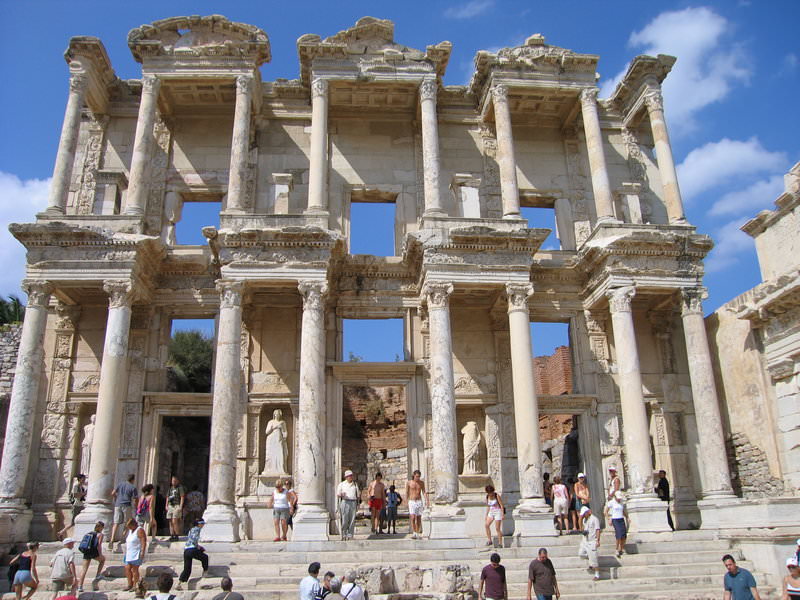
Ephesos Ephesos, which was one of the twelve Ion cities, developed as a result of a union of Ionian immigrants with the natives living near the temple of Kybele. Afterwards, the spectacular temple built for this goddess who then took the name of the Greek Goddess Artemis, would be famous as one of the Seven Wonders of the World. Like the other Ionian cities, Ephesos was ruled by Lydia, Persia, Macedonia and lastly by the Roman rulers. This city was one of the most popular cities of the ancient world and was given a special attention by many Hellenistic kings. For instance it is known that Lysimakhos built this city and gave it his wife Arsinoe’s name, and that the king of Pergamon Attalos II, enlarged the port. Because the Romans made Ephesos the capital of the Asian State, the city became one of the biggest settlements in Anatolia. The city was an important centre for Christianity at this time.
Owing to its wonderful position and associated ports, Ephesos became Anatolia’s biggest trade centre. The Celsus library, a theatre, a stadium, a gymnasium, temples and the famous baths are responsible for this city becoming a sport, religious, cultural and entertainment centre especially in the Roman times.
Myus It is located near Avşar village, 15 kmto the east of Millets, at the shore of the Bafa Lake. Strabon stated that Myus was founded by Kydrelos, son of Kodros, the king of Athena. According to Strabon, it is one of the cities included in the Panionion Union. Herodotus stated that Persian fleet anchored to Myus off-shores in 499 BC. However, Herodotus declared that Myus took part in the Lade Sea War in 494 BC. with only three ships. Dionysus tempest of which name is being mentioned in ancient resources and which is made of white marble has been found during the digs. Today, we see in the city, some parts of Dionysus tempest, and rampart walls of theArchaic Period and the ruins of Byzantine castle.
Sardis Sardis (Salihli/Sart) which was known as the capital of theLydia Kingdom was founded in the VIIIth century B.C. and was ruled by the kings: Gyges, Ardys, Sadyattes, Alyattes and Kroisos. The city was conquered by the Persian King Kyros in 546 B.C. and from then continued to function as a Persian garrison. Alexander the Great conquered the city in 334 B.C. and at that time the city becomes Hellenized. The city was then ruled by Syria, Pergamon and by the Romans in turn.
Sardis was known by its wealth and as a famous trade centre when it was the capital of Lydia Kingdom. Owing to the Paktolos who passed nearby the city and who had rich gold mines the wealth of the city became very famous. This city which minted the first coins in history in the VIIth century B.C., was the last stop on the famous King Road which started in Susa. Moreover, the city earned a considerable income from the famous Artemis temple which people from all over the ancient world visited.
Tripolis It is 40 km to the north of Denizli City centre. It is established in the east of Yenicekent Town of Buldan District, on the slopes between the Büyük Menderes River and the town. It is connected to both theAegean shores and to Inner Anatolia and the Mediterranean with Büyük Menderes plain opening towards thewest.
The city is 30 km to its peer Laodikeia, which is established on Çürüksu Valley in the south of it and 20 km to Hierapolis.
Tripolis are one of the border, trade and agriculture centres providing transportation to Karya and Phrygia regions in Lidia region. Its establishment type and city understanding makes it one of the richest cities of the region. Tripoli is estimated to be established in the Lidian Period. There is no historical information relating to the Lidian, Persian and Hellenistic Periods, yet. No ruins from these periods were encountered, either. The ruins of the city have theRoman and Byzantine Period character in terms of style. Best samples of the monumental buildings are constructed in the1st, 2nd and 3rd centuries AD. In accordance with Pliny, another name of the city is Apolloia. The names of goddess Leto, the Letoia Phthia games and the Menderes River exist on the coins. Tripolis and its surroundings has been the scene for many earthquakes and wars in the history. The name of Tripolis, being called in the list of Lidian Bishops list show that it was a city in bishopric level.
Alabanda It is one of Karia cities, which is founded at Araphisar village that is 7 km far from theÇine District of Aydın. According to Stephanos from Byzantium, the king Kar gave this name to the city upon his son Alabadros’s victory in a horse race. We all learned from Strabon that the people of Alabanda were very rich, lived in luxury and all girls in the city played harp. The foundations of two temples were found during the digs carried out by Mr. Halil Ethem. One of the important works in the city is a bouleuterion. Besides, the tombs seen at the east are the indications that a necropolis existed here. A water arch and a theatre are the other buildings seen in the region.
Alinda Alinda is one of the important Karia cities, which is founded at the Karpuzlu village in the Çine District of Aydın. When Ada, a daughter of Hekatomnos had been driven away by her brother Pixadaros from Halikarnassos, she went to Alinda in 340 BC and made this city capital. The most important structure that still remains standing in Alinda is the agora. A theatre lies at the south-western side of the acropolis. There are two tempest foundations at the acropolis. The Karia type tombs between the Karpuzlu houses are the indication of the fact that Alinda necropolis settled at the southern side of the city.
Amyzon Amyzon is one of the Karia cities, which is founded at the Gaffarlar village in theKoçarlı District of Aydın. For the history of the city, we only make use of the inscriptions. In the 3rd century, Amyzon, who had first been the supporter of Ptolemaios and of Seleukos subsequently, made a bilateral agreement with Herakleia, which was located at lower sides of Latmos at the end of the 2nd century BC. Antiokhos III stated with the message he sent to Amyzon in 203 BC. that he approved the privileges of the city. And the authority for protecting the people who took refuge in the Apollo and Artemis tempest was among these privileges. The ramparts of the city still remain standing and it is built with the isodynamic method used in 300 BC. The Apollo and Artemis tempest, ramparts, underground rooms with the arched vaults and a Byzantine building are the ones, which still remain standing.
Gerga The city, which is founded at the Deliktaş village in Çine District of Aydın, lies at 13 km to the northern-west side of the Alabanda ancient city. There are some traces showing that the history of the city goes back to the Archaic Period. The ruins in the city belong to the Archaic Period and the Roman Period. Gerga is an important place that reflects Karia culture. The city may be qualified as a place that protected its properties due to the fact that it is a city, which is built between the mountains. The rampart walls are typical Karia style.
It is stated in the sources that the name of Gerga can be a city and can also be the name of a God. The most important building is the one, which still remains standing and which has the properties of a temple. It was built of big stones and there is writing on a triangle forehead of the building. It is estimated that the huge statue which has fallen to the lower side of the building belonged to Kybele. It is learned from the sources and the people living in the region that this statue remained standing 20 – 30 years ago.
Nysa Nysa is one of Karia cities within the borders of the Sultanhisar District of Aydın. We obtain the most important information about the city from Strabon who lived in Nysa most of his life. Strabon told that the city consisted of two parts. At the western side of a flood bed dividing the city into two, lays a gymnasium. At the northern side lay the Byzantine ruins and a library. To the north of the library, there is a theatre that carries an importance with its embossments in the stage building. An odeon and bouleuterion are at the eastern side of the flood bed. The necropolis of the city lies on the way to Akharaka, which is a small village in the west.
Orthosia It is located within the borders of the Donduran Village in the Yenipazar District of Aydın. Strabon, one of the authors of the Ancient Period, mentioned about Orthosia as a Karia city. The city which was attacked by the Kimmers in the 7th century BC, passed under the sovereignty of Lydia after the victory of Alyattes, the king of Lydia, against the Kimmers; it participated to the Ionia Union in the 6th century BC and then passed under the sovereignty of the Persians as the other Anatolia cities. The theatre and the Byzantine buildings still remain standing. Well-protected tombs and graves on the necropolis show qualified workmanship.
Piginda According to Stephanos from Byzantine, it is a small Karia city which is located 7 km to the north of the Çamlıdere Village in the Bozdoğan District of Aydın. Our information about the city is very limited as no research has been carried out. In the city consisting of three acropolises, today, we see the ramparts belonging to the Hellenistic Period. A theatre and a holy building which may be called probably Heraion are the important structures. As we have learned from the inscription found in a square planned building, there was the Zeus Pigindenos cult and the Zeus Tempest of this cult in the city. The exact location of this tempest could not be found yet. However, it is estimated to be in Piginda.
Tralleis It was founded within the borders of today’s Aydın. According to the myths, it was established by the Argostians and the barbarian Tralleissians. However, it should have been a city before used by the Karians.After it was occupied by Alexander in 334 BC, dominants of the city had frequently changed among the Hellenistic Kingdoms. It progressed in sculpture in the Bergama kingdom period and the two famous sculptors Apolloio and Tauriskos grew here. The only building that still remains standing in the city, described by Strabon, is a ruin of gymnasion built in the 2nd century AD and called Üçgözler by Aydın people. Necropolis lies in modern Aydın, at northern side of the city. It is being understood from the inscriptions found in the digs and from the articles of ancient period authors that the Zeus Larasios tempest and the Zeus Larasios cult existed in the Hellenistic Period. However, its exact location is not known yet. Besides, an agora, a theatre and a stagium are the other structures of the city
Herakleia Salbake The city is in the borders of the Vakıf village that is 10 km to the north-west of Tavas District. The population is dence in the region surrounded with the water in the north. Herakleia Salbake is located at the skirts of the Babadağ mountain range separating the Caria and Phrygia regions indicated in archaic geography and looking to the current Tavas Plain. It is known as Caria city. Heraklia and Aphrodisias are separated by Tmelos (Kırkpınar) Brook as a natural border.
The river god of both cities is Tmelos. Heraklia is close to and peer of the cities Aphrodisias in its west, Apolloia and Tabai in its south and Sebastopolis and Kidrama in its south-east. No information could be obtained from the archaic sources about the first establishment of the city. The important buildings of the city are: a Roman Period city wall surrounding the city and the a stadium.
Labranda Labranda, is a holy area of Zeus Labraundos, is in ancient Karia (South-western Anatolia), 14 km to the north-east of Mylasa city to which it is affiliated.
The most ancient findings belong to the year 600 BC.The area that was used as holy area in the 6th and the 5th centuries and then as temple terrace consisted of a single, small, artificial terrace. A war took place in the holy area in 497 BC and Karia army has been defeated by the Persian army with its alliances.
The 4th century BC is the most important period for the temple. At the times of the satraps named Mausolos (377 – 352 BC) and Idrieus (351 – 344 BC), this place gained a new appearance. In 355, during the sacrifice festival in Labranda, Mausolos escaped from an assassination attempt on his life at the last moment. Buildings such as a series of artificial terraces, one or two entrance buildings, a small Dor building (probably a fountain building), monumental stairs, two large feast halls (androns), a shed building (called oikoi), Stoa and Zeus Temple surrounded with columns must have been constructed after this event. With the death of Idrieus in 344, such works have been stopped. Because of the big fire disaster that took place in the 4th century BC, the holy area has lost its feature of being a cult place.
The excavation works here were started in 1948 by A.W.Persson and have been continuing with intervals since that time. The current excavations are being conducted by P. Hellström.
The access from Mylasa to the holy area was provided via the holy road which is 8 metres wide. The laying traces on this road can be seen even today. The access to the area was provided with one of the two entrance buildings (propylon). These were impressive passage doors made of Milas marble, having two columns and Ionian frontons on each side.
The building called “Dor building” was located to the east of the southern propylon building with its irregular formation, which resembles a rectangle. It is a building that is turned towards north, has four columns, a front courtyard, a marble side and is in Dor style. It had the function of a fountain building. This small building was included in the bath complex.
The stadium lies 200 m to the west of the holy building. Its back side is reinforced with a retaining wall. The starting and final stones used for the competitions still exist at both ends. It is supposed that some competitions were organized in the holy area here during the feast of 5 days.
Pisidia Ancient Pisidia was a mountainous district bounded to the west and north by Phrygia, to the east by Lycaonia, and to the south by Lycia and Pamphylia. These lands more or less correspond to the Turkey’s Lakes Region plus the mountains to the north of Antalya. Surveys and excavations of this region reveal that it has been continuously occupied since prehistoric times. According to present evidence, the first settlements date to the Upper Palaeolithic. It is possible to follow the development of cultures from höyüks, or man-made settlement mounds, which are found mainly on plains or natural eminences, and this is especially the case with Hacılar Höyük, which lays 25 kilometres south-west of Burdur. Hacılar is one of the most important sites not only for this region but for all Anatolian prehistory. British excavations here from 1957 to 1960 illuminated one of the unknown epochs of Anatolia’s past; the culture discovered here proved to be superior to its contemporaries and to have had its own creative character. Nine occupation levels have been identified at Hacılar, and according to carbon 14 tests, these all fit into the period between 5600 and 4750 BC .In addition, below this, remains belonging to an A-ceramic Neolithic culture dating to 7000 BC were uncovered. Most distinctive of the material remains from Hacılar, is a series of baked clay female figurines. Sitting in various postures, lying or holding a child, these figurines are full breasted and have clearly delineated sexual organs. They can be identified with a Mother Goddess symbolizing the fecundity and abundance of the Anatolian woman.
Hamaxia In the Elikesik village which was located on 6 km north-west of Alanya, within the borders of Pamphylia Region. It is known as Sinekkalesi by public. Strabon mentions that the timber used in ship building was grown in a town and particularly there were cedar trees in the town. It is believed that the town was founded before the Roman period. Rectangular stone shaped tower shows Hellenistic features. The most important ruins of the town include: an antique fountain, a Pool, semi-circle designed, exedra whose seats are still seen still readable inscriptions, a religious complex and a necropolis. Some inscriptions discovered in the town pave emblem of Hermes which indicates existence of the Hermes temple in the town. Considerable parts of an embossed stela ostoteks exhibited in the Alanya Museum were discovered in the town. It is known that a small community not being rich lived in Hamaxia between 100 and 200 AD under the reign of Coracesium. Important part of the ruins is dated from the Roman and Byzantine Period.
Dağlık It is within borders of Güneyköy, 18 km away from the Gazipaşa district. It falls into the borders of region known as Mountainous Kilikya in the Ancient Times. The name of the town comes from Antiochust IV, the king of Kommagene. The ruins are collected on three hills. In the first one is the region consisting of an agora, a bath, a victory line and a church; the second part is the necropolis area having tomb structures unique to Kilikya region; the third part is the ruins of castle built on a sharp rocky area extending to the sea in the west. In the north of the city there is a ruin of a temple whose architectural components are still seen. There is a building having religious functions in apsis of three walls called trikonkhos. The ruins are dated from the Roman, Byzantine and Middle Age Periods.
Selinus 3 km to the south of Gazipaşa about 45 km away from Alanya, the city is on a skirt of a hill extending to the sea in an elbow shape. There is an acropolis of the city on the hill. There is a cradle vaulted two room bath in the point where Selinus (Hacı Musa) meets the sea. The columns of Agora on sea side have been lost but stylobat but their traces can still be seen. When moved toward the east from the Agora a building an apsis is seen. It is probable that the building was established on a religious temple. There is a monumental structure to the east of the church. The entrance door being the only Islamic structure of the city is surrounded with zigzags motives of Lescuklu in colourful manner. This ruin must have been a mansion. The tomb structure on a cemetrey, which is the necropolis of the city, characterises the burying customs of Kilikya in the best way. Some parts of the water canals of the region still survive at present. The Roman Emperor Traianus died in the city while he was returning from mobilisation and his ashes were buried in Rome. The ruins are dating back from the Roman, Byzantine and Middle Age Periods
Iotape Located on the 33rd km of the Alanya-Gazipaşa highway, the antique city got its name from Iotape, wife of Antiochus 4 of the Kommagane king (38-72 AD). The city minted its own coin during the period from the Emperor Trianus to Valerianus. The ruins have features of the Roman and Byzantine Period. The acropolis of the city is a high hill extending to the sea. The castle walls give appearance of a castle. The buildings are destroyed considerably. In the valley where acropolis is connected to the land, there is Harbour street extending in the east and west directions. On both sides of the street, there are crepis consisting of three steps and fundamentals for sculptures. The written fundamentals of the sculptures contain information about successful athletes and charity loving citizens of the town. In the bay located on the east of the acropolis there is a basilica in rectangular shape with three naves. There are traces of frescoes inside the small church in the town. In the frescoes H.G. stratelates were figured. Another building that still remains in the city is a bath. The sewage system of the bath can still be seen. On the modern road passing through the city centre there is ruin of a temple in 8×12.5 m. size. Necropolis of the Iotape is on the north and south hills of the city. Beside monumental tombs there are also small tombs structures covered with vaults.
Syedra Located on about the 20th km of a highway between Alanya and Gazipaşa, within border of the Seki village. The city is entered through a monumental door still remaining on the west of the town. There are several cisterns which provided water needs of the city. The niche caved into the stone in one of the caves is painted with frescoes. The cave must have been used for religious purposes and is known as a baptising cave. There is a bath building on the east of the town. There are mosaics on some part of the bath floor. Just on the west of the bath, in the north-south direction a columned street of the town lies. There are niches on the north walls of the street. In the excavations made by the Directorate of the Alanya Museum since 1994 it was understood that the street is 259×10 metres in size and covered with wooden roof and south is open. There are many inscriptions about races and competition. Other important structures in the town include a temple, a theatre, shops, houses and town walls. The excavations indicated the ruins belong to the period between B.C. the 7th century BC and the 13th century AD.
Laertes Settled down on skirt of Cebel-i Reis mountain elevating at the entrance of Dim valley on Taurus Mountains, about 25 km away from Alanya. The nearest village is Gözüküçük.In the border of the region known as Mountainous Kilikya Region in the ancient times. Strabon mentions the town as having a harbour and being established on a hill in chest shape. The important ruins of the town remaining at present are observatory towers, Caracalla exedra, an Odeon or theatre, Zeus Megistos temple, Apollo temple, Caesar temple, an agora, a bath and a necropolis. Non-existence of ruins from the Hellenistic times is due to the fact that the town was under control of pirates during then and therefore improvement was not made sufficiently. Inscription dating the town from the 6th century BC in Phoenician language and found in the town is exhibited in the Alanya museum. Other important art discovered in the town is a “diploma of a Roman soldier” being exhibited in the Alanya Museum, which gives information about military aspect of the town. The ruins are dated from the Roman period.
Anavarza This site which was known as Caesarea or Anazarbus during the times of the Roman Empire is 28 km to the south of the Kozan District of the Adana province. The small village built just outside the antique city walls is Dilekkaya.
We have practically no knowledge of the history of the city before the Roman Empire era. It was named Caesarea by Emperor Augustus who visited the city in 19 B.C. and it started to be known as “Caesarea near Anazarbus”. Anavarza did not show any significant presence during the first two centuries of the Roman Empire period and was shadowed by Tarsus, the capital of the Cilicia state. Tarsus manages to survive to the present times but lost the majority of its historical monuments. The city Isos, which the Roman Emperor Septimius Severus entered with Pescennius Niger and sided with Severus during the power struggle, was rewarded when the Emperor won his battle in 192 A.D. and became the sole ruler of the empire, started to enjoy its days of glory. In the period 204-205 AD Cilicia became the metropolis of the Isaura and Licaonia states. In 206 AD Anavarza, like other Cilician cities was captured by the Sasani King Shapur. Anavarza which was destroyed by Balbinos of Isaura in the 4th century A.D became capital of Cilicia Secunda (Cilicia of the Plain) which was established during the reign of Theodosius II. The city was badly hit with an earthquake in 525 and was later restored by theEmperor Justinianus and renamed Justiniopolis. In 561 it experienced a second earthquake disaster and in the 6th century was hit with a major plague epidemic.
During the chaotic centuries which followed the rise of the Islam, Anazarbus remained as a buffer zone between the Arabs and the Byzantines and frequently changed hands between the two sides. In 796 Harun el Reşid re-built the city and the Caliph Mutacvakil (846-861) rebuilt the Sis castle and carried out active work at Anazarbus. His name is mentioned in an inscription piece in Kufi language found at the ruins of tower located outside the west gate. In the 10th century when Aynı Zarba was once more on the brink of ruin, Hamdanid al-Dawla turned it into a fortified settlement by spending the tremendous sum of three million dirham. The city then became the focus of interest of the Byzantines again and during the 964 campaign which ended in victory, Nicephorus Phocas took over Anazarbus along with several important fortifications including Tarsus and Mopsuhestia. In the 11th century, the Armenians whose capital was conquered by Alpaslan were driven towards southwest under the pressure of theSeljuk Turks and establish a kingdom in the Taurus region. Later on, they slowly progressed towards the Cilician plain and there chose Anazarbus as their capital until the year 1100. Except a gap of 7 years, when the Byzantines again gained control under the rule of John Commeneus between 1137-1144 the city remained as a capital for almost for a whole century. In 1184 Tarsus and later Sis became the capital. Despite the fact that Anazarbus remained as an important fortification, the city which was built lower down, on the flat plan eventually started to be destroyed. It was finally totally ruined when the Memlüks destroyed the Little Armenian Kingdom in 1375 and this antique settlement has never been used again since.
The ruins in Anavarza consist of a 1500 metre long city wall with 20 bastions, four entrances, a colonnaded street, and ruins of a bath house and a church. Important works also include the theatre and the stadium outside the city walls, aqueducts, rock tombs, the necropolises in the western side of the city, the antique road which was constructed by splitting the rock mass and the pooled mosaics which are conserved in situ (the mosaic of the sea goddess Thetas from the 3rd century AD), the victory arc with three entrances, which is the only example of its kind in the Adana region and the castle from the middle ages on the hill which rises like an island in the centre of the plain.
Colossae It is 25 km to the east of Denizli Province, and 2 km to the north of Honaz District. The highway going to Honaz from the Organized Industrial Region that is at the 16th km of Denizli – Ankara Highway passes through Colossae city. The archaic city is established in the north of Honaz (Kadmos) mountain, on the shore of the Aksu Brook. It is on the south-east way that had been used since the Archaic Period. It is one of the most important centres in Big Phrygia. In accordance with Ksenophon, it is one of the 6 big cities of Phrygia.It has lived its bright eras under the Persian sovereignty. Beginning from the 2nd century BC, it has lost its importance with the establishment of Herapolis and Laodikeia. At the beginning of the 1st century AD, wool and weaving industry has developed in Laodikeia. It has been destroyed with the earthquake that took place in the 1st century AD in the Nero Period. In the Late Roman period, Hierapolis and Laodikeia become villages due to migration. It was completely abandoned in 692 – 787 AD, because of the city Chonae was established at the location where today’s Honaz District centre is located. We learn from the ancient sources that St. Michael church existed in Chonae city. But there are no ruins today. There is a fort ruin belonging to the Ottoman Period on the hill. The ruins of Colossae archaic city are encountered in the lands at the top of the puin place that used to be an acropolis and its surroundings. There are room and house type graves cut in the rock in the region in the south of the ruin place.
Magnesia Ad Meandrum Magnesia ad Meandrum is located on the Ortaklar – Söke Highway, within the borders of Tekin village in Ortaklar quarter of the Germencik District of Aydın. According to the ancient resources and the myths, the city was established by a tribe which came from Thessalia and were called the Magnets. Nobody knows the exact location of first Magnesia, which was founded by Magnets who landed at today’s Bafa Lake that was a small bay under the leadership of Leukippos and divination of Apollo; but it was estimated that it was located at the edge of the Menderes River.
The Magnets re-built a city near Gümüşçay in B.C. 400 because of the epidemics which arouse out of overflow of Menderes and because they had to defend themselves by building a more secure city against The Persians. Magnesia, which was dominated by Seleukos first and the Bergama Kingdom subsequently in the Hellenistic Period, maintained its importance in the Rome Period and had been the Episcopal centre during the Byzantine Period. Magnesia was a city surrounded by ramparts that covered a 1, 5 km diametre area, having a grating planned street and a road system and had been a commercially and strategically important location among triangle of Priene, Ephesos and Tralleis. The Magnesia Ancient City had not been subject to much destruction. The overflow of the river and the silt layer brought by rainwater from Gümüş Mountain had a great effect for this situation. The first digs in Magnesia were carried out by Carl Humann on behalf of the Berlin Museum in 1891. A Theatre, Artemis tempest and altar, an agora, Zeus tempest and prytaneion were found partially or completely during these digs which lasted 21 months.
The works found in Magnesia are being exhibited in Paris, Berlin and İstanbul museums. The digs were completed in 1893, and 100 years later, the digging activities re-started in Magnesia, which was about to disappear, in 1984 on behalf of the Ministry of Culture and the Ankara University. The fame of Magnesia results from Hermogenes, the architect of ancient times. According to the Architect Vitruvius, an author of the ancient times, Hermogenes is the first architect who applied an octagonal pseudodipteros tempest plan. Vitruvius states that the main work of Hermogenes is the Artemis Leukophryene tempest in Magnesia. The tempest of Hermogenes was built in the Hellenistic Period (the 3rd-2nd century BC), on the ruins of the Artemis tempest belonging to the Archaic Period (the 6th century BC). The tempest is the 4th biggest tempest of the Anatolia in Ion style with 8 x 15 columns and with 67,50 x 40 metres dimension. There was an altar in front of the tempest, which pioneered the Bergama Zeus altar with its “U” formed plan. The altar was ornamented with embossments and statues heights of which were two-man lengths. Another important structure in Magnesia is a theatre, which lies under the ground today. The Magnesia theatre (end of the 2nd century BC) is one of the unique works that complies with the general theatre plan given by Vitruvius. The Agora and Zeus tempests, which were supposed to be built by Hermogenes, are the other works that are re-covered with soil after the digs carried out 100 years ago. The front side of Zeus tempest located in the agora, which is considered one of the biggest shopping areas of the period with its 26,000 m2 area, is being exhibited in the Berlin Bergama Museum. The other buildings seen in Magnesia today belong to the Roman Empire Period. The other works known in Magnesia are as follows: a Gymnasium which is a training centre especially for sports, a bath which is small copy of the Faustian Bath in Millet, an Odeon between the theatre and Artemision, a stadium of 25.000 people capacity, an unfinished building with theatre plan, shopping area basilica, a Byzantine building characteristics of which are not known yet and a Byzantine rampart also surrounding Artemision. The 15th century Transversal planned the Çerkez Musa Mosque is the only Islamic building of the ruin. Tour around, see and introduce yourself to this ruin which is one of our ancient cities along with Ephesos, Millets, Aphrodisias and Hierapolis which are being studied by foreign teams.
Klaros Situated in the Kolophon territory in between the cities Kolophon and Notion was the city of Klaros. It was the centre of the Apollo Klarios cult. There was also a huge temple in the city which was an oracle centre especially during the Hellenistic period. Visitors from all corners of the world, kings, city representatives and ordinary citizens came to consult the God Apollo’s Oracle. The temple was plundered at times by pirates but had vast financial revenues during the Roman Times.
Laodikeia Archaic Laodikeia city that is 6 km to the north of the Denizli Province is established at a very suitable point from the geographical point of view in the south of the Lycos river.The name of the city is mostly referred to as “Laodikeia” at the side of Lycos” in the archaic references. In accordance with the historian Pliny, Laodikeia has been constructed on the ruins of a village that was first called as Diospolis “City of Zeus” and then as Rhoas. The name Diospolis is a symbol of the importance given to Zeus cult there. The name Rhoas may belong to any of the native Anatolian languages.
In accordance with other archaic sources, the city was established by Antiokhos II between the years 263 – 261 BC and the name of Antiokhos’s wife, Laodike, has been given to the city. Laodikeia is one of the most important and famous cities of Anatolia in the 1st century BC. The big artistic works in the city belong to this period and the gladiator fights promoted the growing importance of the city. The Romans have given a special importance to Laodikeia. Famous statesman and preacher Cicero came to this city in 50 BC and dealt with some legal problems of the city. Again at those dates, the Romans have made Laodikeia the centre of Kibyra convents. The Roman Emperor Hadrianus visited the city in 129 AD and wrote letters to Rome from there,
Evidence shows that how good the relations between the City and Rome were the status, wealth and privileges that Zeno family had. A man named Polemon from this family has been assigned as a director to Kilikia and Pontus by Antonius.
The inscriptions and coins provide information about the religious life of Laodikeia. Zeus Laodiokos figure seen on many coins belonging to the Empire period is the indication of the importance given to Zeus cult in this city. The information we have in relation with the late periods of Laodikeia is very limited.
A few texts provide information to us about the condition of Laodikeia during the beginning periods. As is the case for other locations, Christianity has affected the Jewish community first.
Existence of one of the famous 7 churches of Small Asia in this city shows the importance of Christianity in this city. We don’t know the reason why Laodikeia that was established near Goncalı and Eskihisar villages in archaic period was completely left. But, it is not difficult to guess that big earthquakes played a role in this event.A very big earthquake that took place in 194 AD and destroyed the city.
Hattusaş The historical site of Boğazköy (Hattusas) is located at 82 km to the southwest of Çorum and it is 208 km from Ankara. Boğazköy (Hattusas) site which was located at the core region of the Hittite state is at the southern end of the Budaközü River valley, at an elevation of 300 metres from the plain surrounded by numerous rock masses and the separations of mountain sides and deep cliffs to the north and west. The city is open towards the north and surrounded by city walls on all sides except the north.
The Hattusas historical site was first visited by Charles Dexter in 1834 and introduced to the world. Later Sayce made the first connection between with these ruins and the Hittite state as until that time the centre of the Hittites was considered to be in Syria. In 1882, Carl Human came to Boğazköy with Otto Puchstein and they, for the first time made a comprehensive planning study. They also made castings of Yazılıkaya which is currently at the Pergamon museum. During the years 1893-1894 E. Chantre carried out the first explorative excavation and in 1905 Makridi and H.Winckler visited Boğazköy and carried out the excavations which continued until 1917. The systematic excavations which were started in 1932 by Kurt Bittel on behalf of the German Archaeological Institute were stopped for a while during the World War II and the work was later resumed and continued under the same excavation leader until 1978. The excavations which are carried out under the leadership of Dr. Peter Neve from 1978 to 1993 is still progressing on behalf of the same institution by Dr. Jurgen Seer.
Settlements existed at the Boğazköy (Hattusas) site since 3rd millennium B.C.. The small and fortified settlements of that period were at Büyükkale and its environs. In the 19th and 18th centuries B.C. settlements from the age of Assyrian Trade Colonies are seen at the Lower City and the name of the city was first discovered from written documents of that era.
The first period of development at Hattusas terminated with a major fire and the culprit behind this fire must be the Kushara King Anitta. According to documents, right after this destruction, around 1700 B.C.. Hattusas was settled once more and became the capital of the Hittite state in 1600’s and its builder was Hattusilis I. who had a Kushara origin just like Anitta.
After Hattusas became the capital, a monumental building development can be seen at the farthest point of the spreading settlement and the city took its 13 century B.C. form with 2 km wide palace and temple districts. In the second development period of Hattusas three important Hittite kings played a significant role during the last years of the Empire. They were Hattusilis III, his son Tudhaliyas IV, and his son Suppiuliumas II. When the Hittite state was destroyed due to economic hardships and internal strife during the last years of the Suppiuliumas II reign (1190 B.C.) Boğazköy was abandoned for a period of 4 centuries and the first settlement seen after this gap is Phrygian (middle of the 8th century B.C.) During the Hellenistic and Roman times (the 3rd century B.C. – the 3rd century A.D.) Hattusas is a fiefdom centre surrounded by a small wall and it appears as a village during the Byzantine period.
The part of Hattusas known as the Upper City is a sloped land of more than 1 square kilometre. This area has witnessed the development of the city during the late Empire Period in the 13th century B.C.. A major part of the Upper City solely consisted of temples and sacred places. Upper City is surrounded at south by a city wall which draws a large arch and this wall has 5 gates. At the furthest southern point of the wall and at the highest point of the city, the gate with the Sphinxes is located with its bastion rising above anything else. Of the other four gates the two facing one another at the southern and western tips of the city walls are the royal gate and the gate with the lion.
Yazılıkaya Yazılıkaya which is located 2 km to the northwest of Hattusas historical site was the Open Air Shrine of the Hittite Empire. It was built of a natural rock and consists of two rooms and a Hittite temple in front of it which and reflects the characteristics of the Hittite architecture.
In Yazılıkaya open air shrine there is a Big Gallery named Room A, and the Small Gallery, named Room B both of which are built into natural rock.
The west wall of the Big Gallery (room A) is decorated with god reliefs while the east wall is decorated with reliefs of the goddesses and the figures on both walls face the section where the main scene is and the east and west walls join the north wall. The gods generally have pointed hats, short garments belted at the waist, shoes with upturned points and earrings. Most of them carry a curved sword or a mace. All of the goddesses wear long skirted garments and on their heads sit cylindrical head dresses. On the north wall where the east and west walls meet there are the chief gods, composing the main scene. Here we see the Mountain God Teshup standing above the air gods, his wife goddess Hepatu and their son Sharruma and a double headed eagle. The relief of the King Tuthalia IV is on the east wall and it is the largest relief of the gallery.
The Small Gallery (room B) which has a separate entrance is protected by a winged, lion headed and human bodied genie placed on both sides of the entrance. There are twelve gods proceeding towards the right on the west wall of room B and the God of Sword and the King Tuthalia IV who is under the protection of God Sharruma on the east wall. Besides the well preserved reliefs, this section has three niches carved into the rock which are assumed to be used for some gifts or the ashes of the Hittite royal family. With all these features and the addition of the spaces built at the front, Yazılıkaya has survived to our times as a Hittite shrine.
Adada Adada, an ancient city in the Pisidia region, is near the village of Sağrak of İsparta’s Sütçüler township. The city rests to the south-east of İsparta and the Lake Kovada. You can reach Adada after driving 50 kilometres past Eğridir on the road that goes to Sütçüler. It is also possible to reach Adada from the Kovada-Eğridir junction on the new Aksu road that connects İsparta and Antalya, but some parts of the road are as yet incomplete. The ancient city is surrounded by hills blanketed by pine and juniper trees. Adada is one of the few ancient cities in Turkey that has managed to survive to our day with very little damage. This place is called the Karabavlu Valley by the locals. The old names for Sütçüler, Baulo and Karabaolu or Karabavlu, are believed to originate from the name St. Paul. These two settlement areas on the Eprge-Antioch (Yalvaç) road were travelled by St. Paul.
Some researchers believe that the word Adada comes from the Luvice language, a language of the old inhabitants of Anatolia, or from the Pisid language, a language which succeeded the Luvice language. Although this is not certain, the word “Ada” might have been formed from the “wanda” or “anda” suffixes. The word “Ada” could have also been derived from the word “Uda” (fortress) and some other words.
Excavations looking into the area in the prehistoric times show that Pisidia was an important cultural centre in Anatolia starting about 7,000 B.C., during the Neolithic times. Excavations in the area between the Tarhuntassa region of the Hittites, which covered Konya and its surroundings, and the west of Pitassa (the old name of Pisidia) are expected to reveal important clues about these prehistoric times.
The name Adada was given to the city of Artemidoros, according to the first-century B.C writer. (Strabo XII, 570). Later Ptolemoios (V 5,8) and the Byzantine historian Heracles (647,4) refer to the city as Odada. However, the city has been dated back to the second century B.C. due to an agreement document found in Termessos. This friendship agreement between Odada and Termessos, another important city in the region, was signed against Selge, a common enemy of the cities. Historical sources say that Selge, especially during the Hellenistic times, followed an imperialist policy against Termessos and it fought against cities around it, including Pednelissos. The agreement put forth that Adada and Termessos would help each other in fighting Selge and also against the enemies of democracy in these cities. Some researchers believe that rather than Selge, the agreement was signed against the Kingdom of Bergama, which had become very powerful at that time and tried to destroy democracy in Termessos. Through this agreement, the sides committed themselves to help each other should either be attacked or faced any threat against their democracy. This agreement was very important for both Termessos and Adada since it helped both cities to gain a democratic administrative structure and also take on the status of a “city-state,” or “polis.” Researchers think that the agreement was signed sometime in the period of 190-164 B.C.
Another important implication of this agreement is that people of Termessos and Adada had blood ties. When one examines the evidence closely, it can be seen that there are many names from the Termessos and Adada people in this text. The Kingdom of Bergama, through a testament, left its land to Rome in 133 B.C., thus beginning the era of the Roman dominion in Anatolia. In this age, unlike western Anatolian cities, most of the Pisidia cities managed to stay independent. The independent city of Adada printed its first coins during this time. Again in the Pisidia region, especially during the time of Augustus, the Coloni cities which were a symbol of the Roman sovereignty were established. The most important of these cities were Antioch (Antakya), Kremna and Komama.
In the days of the Roman Empire, the rules of the Emperor Trajan, Hadrian and Antoninus Pius (114-161 A.D) were the best times for Pisidia and for all of Anatolia. In this peaceful era which was called “Pax Romana,” the cities of Pisidia developed and new buildings were constructed in line with the increasing wealth. In 212 A.D. a law was passed granting a Roman citizenship to everyone living on the empire’s land, and this further increased the prosperity and wealth of people. However, these developments slowed down by the end of the third century A.D.
According to the Greek historian Strabo, “The Pisidians, who lived in the mountains used to live as tribes ruled by the Tirans, just like their neighbours the Kilikians (Kilikyali) and they used to be pirates” (Strabo VII-3). The strongest characteristic of the Pisidians was they loved their independence, and they were warriors. The best example of this was the people of Sagalossos who put up a valiant fight against Alexander the Great. This shows that military ventures made up one of the main sources of income for the Pisidians.
Like other Pisidians, some citizens of Adada left their homes and served in the armies of the Hellenistic kings as mercenaries after the time of Alexander the Great. Tombstones of these mercenaries in Cyprus and Fenike (the city of Sidon) bear witness to this.
When the Roman Empire was divided into two in 395 A.D., the region continued to exist under the Eastern Roman Empire, later the Byzantine Empire, for many years. Starting from the early years of Christianity, there was a growing interest in this new religion. St. Paul and Antioch (Antakya) visited this area. St. Paul and his friends came to Perge in Pamphylia for the first time around 45 A.D. After staying in Perge for one day, they went to the Kestros (Aksu) River. They crossed the Taurus mountain range with great difficulty and reached Antioch through Eğridir.
Researcher G. Ercenk wrote that the apostolic route followed by St. Paul on his first mission should be the road that passes through Perge, the Kestros Valley, Adada and Antioch. The duration of his reported journey is quite similar to information provided by other sources, which tends to support Ercenk’s thesis. Moreover, the similarity between the names of Baulo, Karabaulo and Paul (Paulus) also support this thesis, despite the competing theory of researcher D. Frech. Frech accepts the existence of the Perge-Adada road but he claims that this road was built during a later era.
Some documents show that the first official church organization was built in the fourth century AD in this region and a number of cities in Sagalassos, namely Kremna, Selge, and Adada, became centres of the episcopacy. Again, documents show that Adada housed the assistant bishop of Antioch in Pisidia. Adada sent representatives to religious councils that convened in a number of cities in 325, 381,451, 692, and 787 AD. This shows that Adada was an active city until the ninth century.
Much later when Anatolia was conquered by the Turks, the Byzantine Empire started to shrink and move towards the west. First there was a resistance in the Pisidia region against Seljuk sovereignty but in 1203 A.D. Kilic Aslan III invaded Ispara and placed Turkmen nomadic tribes ruled by Hamid Bey in Eğridir and Yalvaç. Later in this area, the Hamidoğullari Principality was established, which was later taken into Ottoman territory between 1390 and 1422. Since then, Adada has been an area of ruins. In 1970, the Yeniköy was built across the ancient city, which helped visitors to come here more easily. In recent years, as Anatolia has gained prominence as a tourist destination, Adada has also become a very popular spot for a large number of tourists.
Aizanoi Ancient City This city is in the Çavdarhisar township, 57 kilometres from Kütahya’s city centre. The city experienced its golden age in the second and third centuries AD and became the centre of episcopacy in the Byzantine era. The city has a temple built for Zeus which is the best-preserved temple in all of Anatolia. There is also a large theatre and a stadium adjacent to theatre. There are two Turkish-style baths, one of them decorated with mosaics, plus a gymnasium, five bridges on Kocaçay which are still used today, an old dam, a trading building, and avenues with columns on both sides, necropolis areas and the sacred cave of Metre Steune. The German Institute is still carrying out excavations in the city.
Historical research and monuments (Klaus Rheidt)
At the upper part of the Penkalas (Kocaçay) River, there were the Phrygians who lived around the sacred cave of the goddess Metre Steunene, who was the born through the union of the water nymph Erato and the mythological hero Azan. The city Aizanoi might have taken its name from Azan. Aizanoi was the main settlement of the Aizanitisians, who lived under the rule of the ancient Phrygians.
Recent excavations done around the Temple of Zeus built on the high plateau of the city revealed several levels of settlements dating from as far back as 3000 B.C. In the Hellenistic era, this region was ruled by, alternately, Bergama and Bithynia, and in 133 B.C. it entered the dominion of the Roman Empire. Aizanoi printed its first coins in the second and first centuries. During the days of the Roman Empire, the town became rich from its production of grains, wine and wool. By the end of the first century, the town had started to turn into a city. It was the centre of the episcopacy in the early Byzantine period but it lost its influence in the seventh century. During the time of the Seljuk Principality, Çavdar Tatars used this area as a military base in the 13th century. This is why this area was called Çavdarhisar (“hisar” means city walls).
Aizanoi was rediscovered by European travellers in 1824 and studied in the 1830s and ‘40s. In 1926, M. Schede and D. Krecker started excavations under the auspices of the German Archaeology Institute. In 1970, R. Naumann began these studies anew, and they have continued to the present day.
The city and its bridges
Most of the structural remains that have come down to our day from Aizanoi that are located on both sides of the Kocaçay River (Penkalas) were built during the Roman era. On both banks of the river, there were protective walls made out of large cut stones to protect the city against the rising waters of the Kocaçay, waters which still rise today. Two out of the four bridges on the river are still in use today. The low wooden bridge on the north was used as a pedestrian crossing.
The stone bridge with five arches that follows this wooden one is still in good shape. There is another one with three arches which has fallen into ruins. This one is followed by the city’s main bridge, which today supports all of the traffic with its five arches.
The inscriptions on the pedestal of the bridge’s railing tell us that the opening ceremony of the bridge took place in September 157 A.D. The inscription and two relief-decorated railings are today displayed in front of the fourth bridge. The relief shows the sea voyage of M. Apuleius Eurycles, who financed the bridge’s construction. Eurycles represented Aizanoi in Athens from 153 to 157 A.D. in the Hellenic Union called Panhellion which was established by the Roman Emperor Hadrian. Eurycles returned to Aizanoi in the fall of 157 A.D. In 1990, the bridge was fortified with new railings.
The Temple of Zeus
Recent excavations have shown that layers of remains from the early years of the area were displaced to build the Temple of Zeus. Ceramic pieces dated to the Early Bronze Age were found at the level of the temple courtyard. The rubble from the removed layers was used to the fill temple area. The construction of the temple began in the second quarter of the second century. The money needed for the temple’s construction was met by renting out large temple fields. However, the people who rented these fields resisted paying any money for many years. The construction started only when the rents were paid under the instruction of the Emperor Hadrian. The correspondence between the city and the emperor on this subject was so important for Aizanoi that it rests in the northern side of the pronaos (front gallery) of the temple. On the outside of the same wall, there are long inscriptions. This inscription talks about M. Apuleius Eurycles, whom we know from the bridge inscription. The inscription praises Eurycles’ virtues and his contributions to the city.
On the cut stones of the temple, there are war scenes, horsemen and horses. These drawings depict scenes from the lives of Çavdars, who were looking for shelter in the city walls surrounding the temple in the 13th century. In the peristasis, there are eight Ionic columns on the short and 15 on the long sides. The distance between the interior structures of the temple (pronaos, cella and opisthodomos) is twice as large as the distance between the columns. Therefore this is a temple based on a pseudodipteros plan. The temple is built on a podium with the dimensions 53 metres by 35 metres and the base is covered with vaults, the combination of which makes for an unusual model in the Roman architecture in Anatolia; no similar example has been found. It is believed that the underground chamber under this whole area covered with cella, opisthodomos and pronaos was the staging ground for ceremonies in the cult of the Anatolian goddess Cybele, who was worshipped under the name Metre Steunene in Aizanoai. On the north-west pediment of the temple, on the middle acroter, there is a portrait-sculpture of a woman. This demonstrates that the temple was also devoted to the Phrygian goddess Cybele. However, recent research shows that the temple cannot have been devoted to both Zeus and Cybele. This underground place is thought to be a prophecy centre or the storage room of the temple. The acroter in the shape of a woman’s head has now been placed near other discovered pieces.
Agora, heroon and courtyard with Doric columns:
The Temple of Zeus was the first of the magnificent structures built in Aizanoi’s new city centre on the west bank of the Penkalas river (today’s Kocaçay).A heroon that was considered a small temple in that time and an agora surrounded by galleries were built in the middle of the second century A.D. The area is surrounded by gallery of Doric columns which were built before the gallery that circles the temple. Most of these magnificent structures came to be under village houses and schools, and very few of them are visible any longer. Right next to the road that passes from the south-eastern side of the temple’s flat area, there is a heart-shaped column of the agora. The courtyard with Doric columns is covered with horizontal columns of the Middle Age city walls, and architectural pieces of the other ancient structures. The northern corner of this courtyard was excavated in 1997. The eastern corner of the courtyard with Doric columns and the rest of the places in the courtyard were excavated in 1981-82. You can see the remains of a flight of stairs on the southwest wall of the heroon that stands on the marble-covered podium. This structure is believed to be the tomb of a leading figure of the city.
The Turkish bath and the remains of a round structure: Between the stadium and the temple, there used to be a Turkish-style bath with rich decorations and a courtyard with columns in the front that was built in the second half of the second century A.D. The south-eastern half of this symmetrical structure was excavated in 1978-81. The rich marble covering of the Turkish bath, water and water heating channels can still be seen today. The main bathing rooms like the frigidarium and calidarium are in the middle of this building. There are many side rooms opening to this room. In the largest room, there is a marble sculpture of the goddess Hygenia in an apse. In front of the northeast part of the Turkish-style bath, there used to be a large square courtyard (palaestra) for sports activities. The large stone blocks found in the fields north of the palaestra show that there could have been a splendid tomb here, round inside but polygonal on the outside.
Stadium and theatre
The combination of the stadium-theatre in Aizanoi is unique. Excavation and research carried out from 1982 to1990 showed that the construction of the building started in 160 A.D. and continued until the middle of the third century A.D. During repairs to the eastern side of the entrance to the stadium, a number of inscriptions were found and placed in their original places. These inscriptions tell us that M. Apuleius, who was mentioned in the inscriptions of the main bridge, also made substantial contributions to the building of this complex.
Since the sitting rows of the stadium are polygonal, the structure gets wider in the centre. At its widest point, there is a door on the western side. A marble-covered wall is the only façade of the stadium that looks onto theatre. This is at the same time the back side of theatre stage. The marble pieces can today be seen in the north of the stadium. The low pedestal of this façade wall is in a Doric plan. There are two floors and on top, there is the high Attika floor with an arch. The stage of theatre was covered with rich decorations made out of marble. These decorations fell on top of the sitting rows during several earthquakes throughout the ages. Researchers who examined the marble decorations on the stage arrived to the conclusion that the building was originally built as only one story. A second floor was added in later years when expanding the stadium. A very small portion of the marble parts stayed in their original places, which was the front part of the structure made out of cut limestone. Among these fallen marble pieces, there are parts of a frieze depicting a hunting scene.
The Turkish bath:
In the second half of the third century, in the north-eastern side of the city, a second Turkish-style bath was built inside a building formed by large limestone. In one part of this bath, there is a mosaic floor bearing the pictures of a satyr and maenad. In the fourth and the fifth century A.D, the main area of the Turkish-style bath was rearranged and it was used as the episcopacy centre.
The round structure (Macellum) and avenue with late ancient columns:
A little bit south of this place, there is a round building (Macellum) which was used as food market in the second part of the second century A.D. This area was excavated in 1971 and on its partly repaired walls was hung a copy of the price lists of the Emperor Diocletian which he prepared so as to bring down inflation. For example, a physically strong slave would be the same price as two donkeys (30,000 dinar), and one horse was worth three slaves.
The back side of the village house which limits the round door from northeast was excavated between 1992 and 1995. Here, archaeologists found an avenue dated back to 400 A.D. surrounded by galleries with columns. Almost all the column and joist parts were recovered, and this allowed archaeologists to make it stand again. The architectural parts which were not used were placed on the back walls of the galleries. This was also the entrance of the shops where goods were sold.
Equipment was taken from other buildings to build a roof to protect people against sun and rain. Not only architectural pieces, but also sculptures in desolated buildings were also taken and brought here. In front of the northeast gallery columns, on a pedestal, there is an honour inscription about Ms. Markia Tateis from a noble family and a marble sculpture of a flute-playing naked satyr with a panther skin tied around his body. This sculpture today is displayed at the Kutahya Museum.
The relation between the honour inscription and the satyr sculpture shows that the artists of the late ancient period were not so concerned about the content of the art but instead they wanted to decorate this avenue with different artistic elements. The most important building, which was removed to make room for the avenue with columns, was the Temple of Artemis. Splendid Ionic column capitals of the northeast gallery decorated with perpendicular leaves belong to this temple. There is a long inscription that mentions the goddess Artemis along with Asclepius on a piece belonging to the temple. The inscription says that the temple was built during the reign of the Emperor Claudius (41-54 A.D.) Two plates that were found on the ground of the northeast gallery were originally from the triangular pediment of the temple. One of these plates has a picture of a deer which is the symbol of Artemis. The front façade of the temple which has eight columns can be reconstructed using the parts of the Temple of Artemis that were employed in the building of the avenue with columns. This avenue, for whose construction a temple was demolished, existed until the sixth century when most likely it was destroyed by an earthquake.
Avenue with columns and the door building:
The avenue with columns was the main axis of Aizanoi’s city road system. This 450-metre-long road was discovered in a series of drillings in 1991. This avenue with columns was excavated in 1979, and remains of the door building which form the southwest end of the road are visible. This avenue was a part of the ceremonial road leading to the Metre Steunene sacred area outside the city after passing through the main bridge.
Necropolises:
The large necropolises surrounding the city give us an idea about how big the city was. Various kinds of tombs existed in the necropolises including door-shaped tombstones which were typical for the Phrygia and Aizanoi region. These doors symbolize passage to the other world. Most of these tombs belong to the second century A.D., and they bear the name of the person who is buried or who donated it. They also have signs on them showing the tomb’s owner. On women’s tombs, there are pictures of baskets full of wool and a mirror, and men’s tombs are decorated with eagles, lions and bulls.
In 1990 and 1991, archaeologists found two remarkable tomb remains on the sacred road that leads to Metre Steunene two kilometres southwest of Aizanoi. In the tomb that resembles a cross, there are niches to put sarcophagi. A sarcophagus depicting the war of the Hellenes (Greeks) and Amazons is today displayed at the Kutahya Museum.
The structure with four arches (tetrapylon) was turned into a small Byzantine chapel in the Middle Ages (11th and 12th centuries). Here is found the lower part of a marble sarcophagus bearing a picture of Eros. This piece is displayed in the garden of the Kutahya Museum. These sarcophagi and other tomb remains date back to 155 and 165 A.D.
Metre Steunene sacred site:
The cult place of the goddess Metre Steunene, the oldest sacred side of the city, was a deep burrow in a cave which today has collapsed. Here, archaeologists found clay cult figurines in excavations in 1928, and these pieces date back to between the first century B.C. and the second century A.D. On the upper part of the cave, there is a rock throne with steps. Such sacred sites are encountered in Phrygia’s rural areas, and this shows that the Metre Steunene sacred site was used long before the first century B.C. There are two round pits (bothroi) to sacrifice animals, and these could belong to earlier ages of the sacred site. In these pits, people used to kill offerings for Anatolia’s goddess whom they believed to be living in rock formations and the ruler of the mountains and nature.
Dam and stone quarries:
There are two well-preserved dam walls, built in two stages, which were constructed on the Penkalas River (Bedir Dere) to protect the city from floods. These two stages are separated with marble pieces which are mostly seats. On the rocks on the upper parts of the dam wall, there are marks showing that this place was used as a stone quarry in ancient times.
Claros Claros is a prophecy center of Colophon, one of the twelve Ionic cities. Claros is built between two cities; it is 13 kilometers south of Colophon and two kilometers north of Notion. The Temple of Apollo here was a very important center of prophecy as in Delphi and Didim. The oldest information about this sacred site goes back to the sixth and seventh centuries B.C. through the Homeric Hymns. A sacred cave near the Claros Temple of Apollo, which was an important place both in the Hellenistic and Roman eras, points to the existence of a Cybele cult in earlier periods here.
Claros’ Apollo sacred side was first discovered by S. Schuchardt. Later, in 1907, Theodore Macridy found a column of a propylon, a monumental entrance building. In 1913, Macridy worked with Charles Picard and together they found the propulon in 1913. At the same time, they found a large exedra.
The excavations were suspended during World War I and were restarted by Louis Robert in 1950 and lasted until 1961. After 27 years, in 1988, Professor Juliette de La Geniere started a series of supervising excavations. In 1988-1989, during systematic cleaning work, archaeologists found structures that had remained under the alluvium.
The propylon located at the beginning of this sacred site, which acted as an entrance to passengers who came by sea, was built in the second half of the second century B.C. The building was built in Doric style and has a square plan and it rises on three crepises (krepis). There are two columns on its northern side. Orthostats, walls, antes and columns bear the names of children who sang hymns to Apollo and the names of delegates who came to ask for advise from the oracle of Apollo.
There are honor monuments related to the ancient cities, governors of Asian states, and leading personalities of the Roman era on the two sides of the sacred road that passes between the propylon and the temple and ends on the eastern side of the temple. On them, there are marks of bronze sculptures of people who owned these monuments.
The Temple of Apollo measuring 26 meters by 46 meters was built in Doric style. The temple in the peripteros plan (6 by 11 meter columns) rises on a fifth crepis. In the cella of the temple (the room of the cult sculpture), there are also sculptures of Apollo, Artemis and Leto. This shows that here, there was also a cult of Apollo’s sister Artemis and their mother Leto. From the fragments that have been found, it seems clear that the 7-8 meter high Apollo sculpture was standing while Artemis and Leto were also standing. The moulages of these monumental sculptures were reorganized on the western side of the temple. The Emperor Hadrian (second century A.D.) completed the peristyle of the temple whose constructed started in the third century B.C.
There is a small temple that belonged to Apollo under this temple that was built in the Archaic period along with an altar. Under the cella part of the temple there was a sacred place whose stone arcs are seen today and in this place, prophecy was not done by a woman named Pythia as at Delphi, but rather by a male oracle. The inscriptions found in Claros provide no information about prophecies, but a number of inscriptions have been found in Bergama, Sivas, Amasya, Kayseri and Konya that record the counsel of Claros’ Apollo. It is also known that a temple was made for Claros Apollo in Sagalassos, one of the cities of Psidia.
The oldest piece of information about the function of the Temple of Apollo in Claros dates back to the time of Alexander the Great. According to the Greek historian Pausanias, in his dream Alexander was told that he would set up a large new city at the base of Mt. Pagos (Kadifekale). After this dream the, king consulted the Apollo oracle at Claros and asked him to interpret the dream for him. He set up the new Smyrna after the oracle gave him the go-ahead to proceed.
In the prona (entrance part) of the temple, there are two stairs on the north and south, and they unite in a corridor made out of blue marble. This corridor stretching along the east-west line is 0.70 meters wide and 2.10 meters high. The wall altar separates into two and leads to underground halls. The adyton (sacred room) where the prophesising was done is formed by two underground halls with arches. It is under the cella which has the cult sculpture. In the eastern hall with arches, there are bands of stone seats. There is also an omphalos made out of blue marble, which was the sacred stone of Apollo. A similar omphalos was found in Delphi.
The oracle and the secretary were sitting in this hall which was like a waiting room. The hall in the west had no other entrance than the door opening to the hall in the east. The oracle could enter here only in dark and in it there was a rectangular well which kept the holy water. After drinking from this water, the oracle would issue his prophecies by singing in the form of a song. Some 27 meters east of the Temple of Apollo, there is an altar measuring nine by 18.45 meters. Between the temple and the altar, there are four rows of blocks that were used to tie about 100 animals. The stone blocks in rectangular shape with an iron ring on top are unique and they provide valuable information about the procedure of sacrificial ceremonies. There is a stelle on the north side of this place where the ceremonies were conducted. The decretum that was found in Claros tells us that these holidays dedicated to Apollo were held every five years. On the north of the Temple of Apollo, there was another smaller temple in Ionic style along with an altar built parallel to the temple of Apollo. At this altar, archaeologists found a sculpture of Artemis that belonged to archaic period, which shows that this smaller temple was built for Artemis.
Alacahöyük Alacahöyük is located 45 kilometres south of Çorum and 17 kilometres northwest of the Alaca township. The Alacahöyük village is 34 kilometres away from Boğazköy and 210 kilometres away from Ankara.
This tumulus, or mound, was first introduced to the world of science by W.C. Hamilton in 1835 and after that time, it became a place frequented by scientists who visited Central Anatolia. In 1861, G. Perrot stopped by this tumulus and discovered the plan of the square tower on the left and right of the door and one of the orthostats. After this study, Perrot became the first to argue that these reliefs belonged to the Hittite period.
W. Ramsey, who made great contributions to Anatolia’s historical geography, studied the tumulus together with Wilson in 1881 and found a few other reliefs. In 1893, E. Chantre came to the tumulus and found the square corridors among the sphinx, the second door at the end and the door frames. Chantre took the plaster casts of these reliefs and by judging from their themes, Chantre claimed that this could be the door of a temple rather than a palace. Chantre studied the lions on the south of the door with the sphinx and believed that the inscription found on one of these doors was Phrygian writing. Later H. Winckler, who had been working in Boğazköy since 1906, decided to start a search in the tumulus at the invitation of Makridi Bey and İstanbul Archaeology Museum Director Halil Ethem Bey. In 1907, Makridi Bey worked for 15 days at the door with the sphinx and discovered a few new orthostats in front of the door. After drilling a few places in the tumulus, he saw the poterni (entrance) on the northern edge of the tumulus and he compared this to the potern in Boğazköy. The first systematic excavations of the tumulus were started by Atatürk in the Republican era. Hamit Zübeyr Koşay, Remzi Oğuz Arik and Mahmut Akok from the Turkish History Institution began excavations in 1935 which lasted until 1983. The excavations were interrupted this year and in 1997, they were started again by Professor Aykut Çınaroğlu.
Studies and excavations tell us that there were four layers of cultures that existed in Alacahöyük, which was inhabited continuously since the Chalcolithic (copper) Age. These four layers are the Chalcolithic, Old Bronze, Hittite and Phrygian ages, and each of them has 15 different architectural layers.
The Chalcolithic Age: 4000-3000 B.C., layers 15-9
Old Bronze Age: 3000-2000, layers 8-5
Hittite Age: 1800-1200, layers 4-2
Phrygian Age: Since 750 B.C. in the first layer
The first settlement in the tumulus set up in the Chalcolithic Age was established on an area looking to the south, above sea level, and its northern parts were protected with small hills. In this age, architecture only meant stone foundations and sun-dried bricks. The roofs were covered with reeds and compressed soil.
There were 13 important kings’ tombs in Alacahöyük in the Old Bronze Age, which was followed by the Chalcolithic Age and which was represented by four layers. The tombs which are believed to belong to layers five and seven are located in a special area of the city. Because of their forms, these are considered to be unique tombs of Anatolia and even the Asian frontier. These tombs belong to adult men and women. No children or babies were buried here. In contrast to the tomb types in Central Anatolia, in Alacahöyük there is uniformity in the direction of the tombs and the buried people. The gifts buried along with the dead are the richest and most varied that are found in the Aegean and the Asia frontier in the Old Bronze Age. Among these gifts are sun disks, deer and bull sculptures, decorative pieces, fighting tools such as daggers, swords and axes, and other pieces made out of cooked clay, stones, gold, silver, bronze, and copper. The architectural system of Alacahöyük in the Old Bronze Age depended on the authentic building technique of Anatolia. Buildings constructed using this technique has stone foundations, sun-dried bricks, flat ceilings, plastered floor and earth roofs. The Hittite layers that form the visible part of Alacahöyük are formed by three layers. In this age, a defence system was formed in the form of a circle with a diametre of 250 metres, and on this circle two main gates that were the entrances to the city are found. One of these entrances was the eastern door with a sphinx and the door on the western side of the tumulus.
There are two sphinxes on the south-eastern door, which was the religious door of the tumulus. The heads are remarkable on the sphinx protoms that are carved on monolithic stone lentos. Sphinxes with inflated bodies stay on top of separated short legs. There is also a double-headed eagle carrying a rabbit in his claws in the interior side of the sphinx on the east.
The reliefs under the towers on east and western side of the door with sphinxes are done using low relief technique and the details were given using plastic techniques. Almost all of the orthostats in the western tower are seen as a single frieze. On the lower part, there are pictures on the theme of cult-libation and on the upper part; there are depictions of hunt scenes. The head priest, the king and the queen were depicted as praying in front of a bull during a holiday ceremony which was celebrated to honour the storm god and which was mentioned in Hittite religious texts. Other reliefs depicted other phases of the ceremony. There are pictures of people praying in front of a goddess in the reliefs in the eastern tower, and these show that cult ceremonies were continuing in this age. After entering from the door with the sphinx and passing the entrance complex, on the right you can see the foundation of a large Hittite building which was called Mabet-Saray (Temple-Palace). This building is formed by various storage rooms and other complexes.
Çatalhöyük Çatalhöyük is 10 kilometres east of Konya’s Çumra Township. The tumulus is a hill with two flat areas with different altitudes. Because of these two elevations, it is called “çatal,” meaning fork. Çatalhöyük was first discovered by J. Mellaart in 1958. There were a number of excavations here in 1961-1963 and 1965. The studies made on the western slope of the hill revealed 13 layers. The earliest settlement in the first layer dates back to 5500 B.C. This dating done by examination of style was also proved using the Carbon 14 dating method. The first settlement was a centre that sheds light on the history of humanity with the first house architecture and remains of the first sacred structures.
The best known period of urbanization in Çatalhöyük lie between layers 7 and 11. Houses with square walls were adjacent but the houses didn’t share common walls. Every house had its own wall. Houses were planned separately and one house was built next to another whenever there was a need to do so. Because of the adjacent walls of the houses, there were no streets in the city. Walking on the flat roofs was the only means of getting around. No remains of a fortress or city walls protecting the city have been found. Sun-baked bricks, trees and reeds were used in the making of the houses. The foundations were not deep. There were wooden sticks between the walls, and the joists on these sticks supported the flat roofs. The ceilings were covered with compressed clay earth put on reeds. The houses were one story and the entrance was from a hole opening in the roof. There was a ladder going down from this opening. Every house had a room and storage. Inside the rooms, there were square stoves, stone benches which were 10-30 cm high and square niches inside the walls. The walls were plastered. After the plaster was painted white, pictures were painted on the walls using red and black dyes. Sacred rooms were relatively larger than others. Besides the pictures painted on these walls, there are also heads of bulls, rams, and deer made with compressed clay and applied to the walls. There are also reliefs of people and animals. The wall pictures in Çatalhöyük were found in layers 10 and 11. The most beautiful and sophisticated ones belong to the seventh and fifth layers. These pictures are the continuation of the tradition started by Palaeolithic man, who made pictures on cave walls. They might have also believed that these pictures would bring them luck in hunting. In later ages, we see that home decorations confined themselves to bird patterns and geometrical designs.
The pictures also show headless people being eaten by vultures, a representation which might be related to the residents’ burial traditions. After vultures ate the flesh, the bones were collected and wrapped inside a straw cloth and buried in the house. Excavations in such places have unearthed many skeletons. Archaeologists also found gifts left for dead people such as tools made out of bones, collared stones, sharp tools, stone axes, and beads made out of seashells.
The little figurines found during the Çatalhöyük excavations provide us with new insights about the beginning of the Mother Goddess cult and the religious beliefs of the time. These small sculptures made out of cooked clay and stone measured 5-15 cm high. The female figures are fat and buxom, with large hips. They are sometimes depicted as giving birth. These figurines represent abundance and plenitude. Stone or clay axes, plates, figurines of the goddess of fertility, bracelets and necklaces were the only tools found in Çatalhöyük. There are also black- or brick-collared cups made out of cooked clay. The figurines of the Mother Goddess and sacred animals were also made out of cooked clay. Sharp tools were made out of bones and tips of arrows and spears were made out of obsidian. These were the most important tools used in Çatalhöyük.
No excavation was done in Çatalhöyük prior to 1996. That year, the British Archaeology Institute started excavations under the leadership of Ian Hodder. The remains found are kept at the Konya Archaeology Museum. Some of these remains are being exhibited, while others are preserved in storage.
https://www.kultur.gov.tr/EN/belge/2-20175/antique-cities-of-turkey.html
Leave a Reply
You must be logged in to post a comment.